About Us
Welcome to Spot A Salmon!
If you want to see salmon migrating in real life, in the greater Portland area, this site will tell you where to go and if it is a good time to go. The peak numbers have been declining steadily on average since records began in the 50's ( and ever since the white man settled the west coast). However, salmon runs do fluctuate and there are a lot a factors that influence this incredible event. In the last years the peak numbers have been around 9,000 per day for the spring-run, and 30,000 per day for the fall-run (for Chinook, Coho and Steelhaed). Check the daily fish-count at the top of this website or the charts to see where we are at as of yesterday! Our daily fish counts come from the Army Corps of Engineers data for the Bonneville and Dalles Dam fish ladders.
We built this site because it can be quite difficult for the average person to find this data and wanted to make this information more available and easy to understand for everyone regardless of age. Salmon migration is a small, but very important, piece of the eco-system and you can see how the migration numbers have changed over the years through our interactive charts. For example on April 6th, 1965 there were over 2000 salmon and steelhead moving past the Bonneville Dam, yet on April 6th, 2016 only 169 salmon made it. We hope you enjoy this site, and if you do decide to go catch a glimpse of these amazing creatures show some respect for their journey.
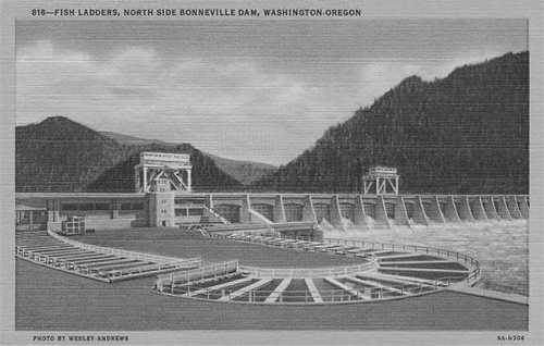
Bonneville Dam Fish Ladder
As the salmon swims, you are __ miles from Bonneville Dam
On the Washington side of the dam is the visitors center where you can see the salmon swim right by some large underwater windows. Nowhere else do you get such close views and the rainbow carpet is also pretty amazing! A little room next to the windows is where the fish counting happens and where we get our daily fish numbers for this website.
Fish that come up this ladder are a mix of wild salmon and hatchery fish, and some of them will go on for hundreds of miles past many more dams, sometimes as far as Idaho or even Canada.
A Public Works Administration project of President Franklin D. Roosevelt’s New Deal, portions of Bonneville Lock and Dam Project were declared a National Historic Landmark in 1987.
Directions: From Portland, OR, 40 miles east on I-84. From Vancouver, WA, 40 miles east on WA 14.
Wheelchair Accessibility: Yes
Fish Viewing: In the Fish Viewing Building, where you can see fish on laddrers and adult salmon in their upstream migration
Restrooms: Yes, inside the Visitor Orientation Building
Reference: ACOE
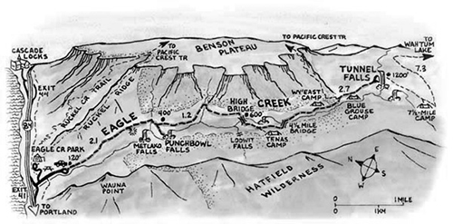
Eagle Creek Trailhead
As the salmon swims, you are __ miles from Eagle Creek
As you walk upriver from the lower parking lot you will come by several pools that in the spring and fall usually hold fish. There is also a footbridge over the creek from where to watch these incredible creatures. Further up near the trailhead is a small dam and a larger pool below where fish will hang out during the migration seasons in spring and fall. These are almost all hatchery-born fish, not wild salmon, and there is no further passage for them up eagle creek.
The Eagle Creek trailhead is a busy place most weekends. Here sits the jump-off point for a half-dozen trails. In addition to Eagle Creek hikers, it accommodates PCT thru-hikers, locals who enjoy the day-use picnic area, site-seers enjoying the nearby fish hatcheries, and campers at nearby Eagle Creek Campground.
Directions: Coming from Portland, travel eastbound on I-84, and turn off at Exit #41. At the bottom of the ramp turn right. Go about 1/2 mile to the end of the road. You will go passed a footbridge (that takes hikers up to Wauna Viewpoint) as the road narrows to one lane. Continue a short ways to a large parking lot, parking only in designated spaces.
Wheelchair Accessibility: In picnic shelter
Fish Viewing: Yes
Restrooms: No
Reference: USDA
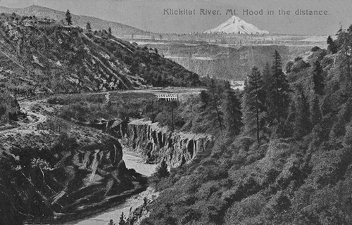
Klickitat River Falls
As the salmon swims, you are __ miles from Klickitat River Falls
This is probably the best place to see salmon in their habitat. The falls provide an excellent opportunity to see the fish jump up the stream, on good days during the fall-run up to 30 or 40 per minute. This is also on of the places where native americans still fish the river with dipping nets, except Sundays and Mondays, so the best time to go is on those days.
The Klickitat Trail is unique among rail trails. Nowhere else is there a rail trail that starts in one of the nation’s only National Scenic Areas, winds along a nationally designated Wild and Scenic River, and finishes by going through a remote, beautiful tributary canyon.
Directions: From the Hood River Bridge in WA turn right (east) on Hwy 14, through Bingen, for 10.6 miles. The Klickitat River is just west of Lyle. Once you cross the Klickitat river bridge turn left onto SR 142. Go 1.5 miles and turn left at sign Fisher Hill Rd. Once under the rail bridge park on the right at a wide spot with the green trailhead gate above you on the railroad bed. Climb the railroad bed and head 0.5 miles upriver towards the roar of the falls.
Wheelchair Accessibility: No
Fish Viewing: Yes
Restrooms: No
Reference: Oregon Hikers
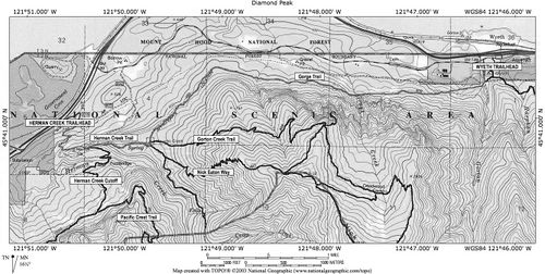
Herman Creek Trailhead
As the salmon swims, you are __ miles from Herman Creek Trainhead
This is quite similar to Eagle creek in that these are mostly hatchery-fish coming up the river. The closer to the mouth job the river, the more fish you should be able to see.
Directions: Take I-84 East from Portland about 40 miles and take exit 44 for Cascade Locks. Take the road through town, East, then under the freeway, continue East on the frontage road on the South side of the freeway for about 2 more miles and turn right on to NW Forest Lane over the Hwy. Access to the mouth of Herman Creek is off Herman Creek Lane, which branches off NW Forest Lane on your right. You can also hike up the Herman Creek Trail about a mile to a footbridge over the creek from where you can spot salmon.
Wheelchair Accessibility: No
Fish Viewing: Yes
Restrooms: No
Reference: USDA